Gps тест для windows

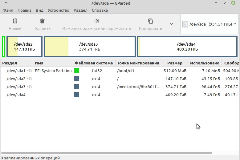
Описание: Программа «GNSS Data Interface» предназначена для обеспечения работоспособности «традиционных» навигационных программ, которые получают данные GPS/ГЛОНАСС через последовательный коммуникационный порт (COM порт).
Операционная система: Windows 7/8/10
Текущая версия программы: 1.2.0.2
Часто задаваемые вопросы: Читать
Скачать актуальную версию:  GnssDataInterface v1.2.0.2.zip ( 1,46 МБ )
Программа «GNSS Data Interface» предназначена для обеспечения работоспособности «традиционных» навигационных программ, которые получают данные GPS/ГЛОНАСС через последовательный коммуникационный порт (COM порт).
Программа «GNSS Data Interface», далее «Программное Обеспечение» предоставляется «как есть», Вы пользуетесь им на собственный риск. Автор не предоставляет никаких других прямых и/или косвенных гарантий или условий. Лицензия на использование Программного Обеспечения предоставляется безвозмездно для использования только в личных целях. Вы вправе установить и использовать Программное Обеспечение одновременно на неограниченном числе компьютеров.
- Программа считывает данные с сенсора GNSS Geolocation Sensor (GPS + ГЛОНАСС) и передаёт их в формате NMEA в последовательный коммуникационный порт.
- В случае если навигационный сенсор выдаёт нативные данные в NMEA формате, таким образом, что в программе навигации мы будем иметь абсолютно всю информацию о спутниках (видимость, азимуты, уровни сигнала).
- В случае, если «родные» данные в NMEA формате не «отдаются» навигационным чипом, то программа производит эмуляцию всех необходимых NMEA данных, как положение/высота/скорость, так и «поддельную» информацию о спутниках (12 спутников).
Например Broadcom чип в Asus VivoTab выдаёт данные в NMEA формате, а чип Ericsson в ноутбуках Lenovo нет - Если пропадает сигнал со спутников или пропадает информация от GNSS сенсора, программа также производит эмуляцию NMEA данных, таким образом, что навигационная программа выдаёт сигнал «Потерян сигнал GPS».
- Из меню программы можно запускать любимую программу навигации, прописав её имя настройках программы, а также возможно настроить и автоматический запуск навигационной программы при старте программы GNSS Data Interface.
- Из меню программы можно открыть онлайн карты Google, Yandex, Bing, OpenStreetMap.
Онлайн карты откроются в браузере по умолчанию с автоматическим указанием настоящего местоположения. - Также есть возможность генерации файлов в формате GPX, KML (для Google Earth) с информацией о пройденным маршруте.
- Конфигурация программы производится через конфигурационный диалог (пункт в меню Options -> Setting, или через кнопку на тулбаре).
- В конфигурации программы можно настроить, в том числе, и автоматический запуск интерфейса с датчиком местоположения (GNSS), автоматическое открытие указанного COM порта.
- В «экспертной» конфигурации вывод NMEA данных поддерживается одновременно до четырех СОМ портов (т.е. нет необходимости использовать программы типа GPS Gate), а также и многое другое.
Инструкция по расширенной конфигурации и дополнительным возможностям:  GNSS Data Interface — extended configuration v1.0 (ru).pdf ( 80,43 КБ )
Gps тест для windows

Download Page
Please read the Conditions of Use before downloading any files.
New users are recommended to download the standard edition of GPS Utility . For a description of GPS Utility see the features page. Because of frequent file format changes, MapsOnUs, GreenFlag and RAC users should use the latest Beta test version. —>
You may download any of the following files:
- GPS Utility Standard edition Version 5.38, Released 5-APR-2021
This file contains the all the files you need to install and run GPS Utility together with a number of sample files to get you going.
This version includes the following new function and program fixes:
- Import of GEONAV 11 *.FSH files
- Import of JVC *.RTN files (initial version)
- Import of Geonav *.MRK files
- Fix for export of Transas *.RT3 files (single route only)
- Import of Quodfish TDB files with format code=11
- Only ask user once regarding replacing waypoints in route
- Fix to the import of Shunhang DAT files
Version 5.37 included:
- Import of Shunhang and Huahang Waypoint and Track files
- Import and export of SAMYUNG DAT files which do not have a file header
- Import of Transas *.MCR files
- Fix to import of Koden files (premature end of data>
- Fixed regression bug in the export of GPX files (missing comment field)
- Fix to Import of GPI files (buffer overflow)
- Minor changes to TimeZero TZD and XML file export
- Change to deal with decimal separator in XML file export
- Deal with reserved characters in Timezero XML file export
- Changes to the import of Seaclear SRW files to deal with comment field
Download EITHER
- the self install exe file (recommended) — run this and GPSU will install itself
 GPS Utility Version 5.38 — (EXE) — 2.30M
 - the ZIP file (for user who are unable to download the EXE file)
— unzip and run the Setup file.GPS Utility Version 5.38 — (ZIP) — 2.23M
Please Note:
As this is a fairly new version, which has not yet been downloaded by many users, your antivirus software (for example, Norton Internet Security) may be over zealous, placing GPS Utility on its blacklist, giving an ‘untrustworthy’ warning message and then quarantining the software. In this case either temporarily disable your antivirus software or download the previous version of GPS Utility (see version 5.27 below), which is trusted. When your antivius software realises that GPS Utility 5.28 can also be trusted, then you will be able to download and install it without receiving warning messages.
If you are upgrading and have your own copies of datums, grids or symbol set files, then take care to back them up before installation.
GPS Utility — Beta Test Version
Beta test version 5.3m is currently unavailable as it has been supperceeded by the current version 5.38.
Version 5.3j Released 04-NOV-2019
This Beta test has been superceeded by the current standard version 5.07. (see above). —>
This is provided for users who have requested new function (for full details see the changes.txt file in the package). The zip file contains files which have been updated since the last standard release. As with any Beta level release, ensure that you have saved all data in GPSU and other programs before using it.
Warning: Version 4.9f contained a regression bug which meant that waypoints were not always begin saved. Please replace 4.9f with version 4.9g as soon as possible and check your data files. Version 5.3j
- Import of Navionics TRK files
- Support for import of Microplot version 7 *.MRK files
- Allow export of Eastings/Northing in CSV files (Formatted — as is option)
- Support for import of GPX file from Mercedes GLE SatNav
- Support Ozi Map calibration file for Transverse Mercator user grid
- Upgrade to *.BIN file import to deal with large numbers of routes
- Upgrade to *.RTZ file export to (deal with double quotes and empty leg tag)
- Allow Waypoint prefixes up to 12 characters
- Automatic route renumbering implemented
- Support for UNIX style of TRK file from Furuno GP1871F devices
- Support alternative date/time format in Haiyang *.MRK files
Version 5.3g
- Fix for Folders. setting (Protected and Photo folder)
- Increased Waypoint and Trackpoint limits
- Provide filter for Own and Other vessel’s track selection in TZD file import
- Provide filter for Routes and Tracks in TZD file import
- Correct Track summary data for tracks spanning E180/W180
- Import of some Micano DAT files
- Fix Import of GPX files for repeated Linestrings — only ask user once for Track or Route
- Initialise track colour correctly
- Inhibit setting Lat/Long when UTM/UPS is set
 GPS Utility Beta test 5.3j (ZIP) — 1.77M
You need to install the standard version (5.33) of GPSU first. Unzip and place ALL the files in the SAME folder as the existing installation (normally C:\Program Files\GPS Utility). You may also wish to arrange a desktop shortcut to point to the EXE file. If you get an error message about not being able to find grid or symbol set files, then check that the desktop shortcut points to the correct EXE file in the program installation folder.
Please send any feedback to the author. —>
Version 1.3, Released 21-FEB-2013
This program drives GPSU so as to convert a batch of files from one format to another format. Recent changes:
- Sizeable window to accommodate longer file names
- Clearer instructions
- An extended list of file types
Download:
- the self install exe file (recommended) — run this and the program will install itself GPS Utility Batch File Converter 1.3 (EXE) — 417K
- the ZIP file (unzip and run the Setup file) GPS Utility Batch File Converter 1.3 (ZIP) — 393K

Version 1.36, Released 26-JANUARY-2015
The purpose of this program is to help with the task of extracting GPS data from ASCII text files and producing a file that is suitable for import to GPS Utility (GPSU). Normally the files will have been produced by a Database or Spreadsheet program in a comma separated value (CSV) or Tab separated form.
Recent changes:
- Remove double quotes from data in rightmost column.
- Accept dates in the form of 2013-07-28 (Y/M/D)
- Allow user specified alignment
- Allow user defined list separator
- Support for Auxiliary data field (Depth, Heartrate, Heading and Temperature)
- Support Timestamps which are seconds from 31/12/89 and Excel days from 1/1/1900
- Provided separate columns for day, month, year
- Deal with Leading zeros for Eastings/Northings
- Support blank lines as tracklog segment breaks
- Deal with dates of the form 12.08.2009
- Deal with empty coordinate fields with an error message
- Support Time format HHMMSS and Date format DDMMMYYYY (i.e. no separators)
Download EITHER
- the self install exe file (recommended) — run this and the program will install itself GPS Utility Import File Converter 1.36 (EXE) — 497K
- the ZIP file (unzip and run the Setup file) GPS Utility Import File Converter 1.36 (ZIP) — 473K
NMEA Utility Version 1.1, Released 12th-Jun-2018
A program for analysing Marine NMEA and AIS file.
Download:
- the self install exe file — run this and the program will install itself
NMEA Utility (EXE) — 1.1M This program requires a separate registration from GPS Utility.
To order please see NMEA Utility
GPSU Olex File Converter Utility
Version 1.16, Released 13th-Oct-2018
A program for converting OLEX files to/from GPS Utility Format Files.
Download:
- the self install exe file — run this and the program will install itself
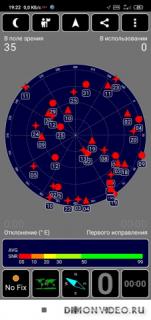
GPSU Olex File Converter 1.16 (EXE) — 447K GPS Test 1.6.3

Android — навигация
Проверьте прием GPS в вашем районе, обновить данные AGPS для ускорения времени исправления все это и простой внедорожный навигация, а также.
Поддержка GPS, ГЛОНАСС, GALILEO, SBAS, Beidou и спутники QZSS.
Функции навигации могут заменить ваше приложение ‘Car Finder’, а также использоваться для геокэшинга. Он записывает неограниченное число сохраненных местоположений, так что вы можете перемещаться по простому маршруту.
GPS Test Plus имеет пять экранов полную информацию: —
1) сигнал GPS (SNR) Гистограмма, показывающая уровень сигнала для каждого спутника, а также точность и состояние GPS.
2) положения спутников в небе (SkyView), как показано на вращающемся компаса.
3) Ваше текущее местоположение на земле показано в виде текста и на карте мира. Текущее положение солнца и кривой перехода день / ночь также показано на рисунке.
4) Компас или навигации инструмент.
5) Полностью настраиваемый вид приборной панели, показывает текущую скорость, курс, высоту и другие поля в виде текста или в виде циферблатов.
6) Текущее время чтения с GPS и местное время в текущем часовом поясе, а также восхода и захода солнца в данном месте.
Полезно для навигации или тайников.
Поддерживаемые координат Сетки: —
OSGB, UTM, МГРС, USNG, CH1903, Maidenhead.
Поддерживаемые Датумы: —
WGS84, NAD83, NAD27, ED50, AGD66, AGD84, SAD69
Все особенности теста GPS, а также: —
* Спидометр, альтиметр и компас циферблаты.
* Семь сегментный дисплей шрифта.
* Точечным шрифтом матричный дисплей.
* Режим отображения HUD для ветровых стекол.
(На дисплее отражается так, что он показывает правильный путь вокруг, когда телефон находится на приборной панели автомобиля и отражение рассматривается в лобовое стекло).
* Доля местоположение.
* Импорт и экспорт путевых точек в GPX и KML форматов.
Приложение имеет несколько цветовых схем, которые могут быть использованы, чтобы соответствовать другие приборы, используемые вдоль стороны приложения. Она имеет «Ночной режим» цветовых схем, а также.
Работает большие таблетки экрана и в новом режиме Android 7.0 разделенного экрана.